MARPO_DREDGER
SPE Dredging Solutions GmbH MARPO-DREDGER programme explains how the hardware and software for the extraction control system, that we developed ourselves, works. In order to offer you reliable and high-quality performance, we have exclusively used robust components of industrial quality.
First of all, with the help of a DGPS receiver with a digital compass, the position of the mobile dredger is established using satellite navigation. Then, the working depth of the excavation apparatus is determined with the help of appropriate sensors (pressure and inclination gauges, etc.). The data is analysed by computer, and fed into a digitalised, colour model of the extraction area. Finally, the dredging operator can have all the data displayed on a TFT touchscreen monitor on board the dredger (which is also used to operate the system), in split view, as a 2D site plan or 3D view, in a user-defined profile section display or in full screen mode.
Additional information for the extraction area can be obtained with the help of echo sounders. The depths measured by the echo sounding sensors are displayed in the site plan as depth on the extraction machine, and, if specified and ordered by the customer, augmented with other operating data, (e.g. pump speed, pressure, etc.).
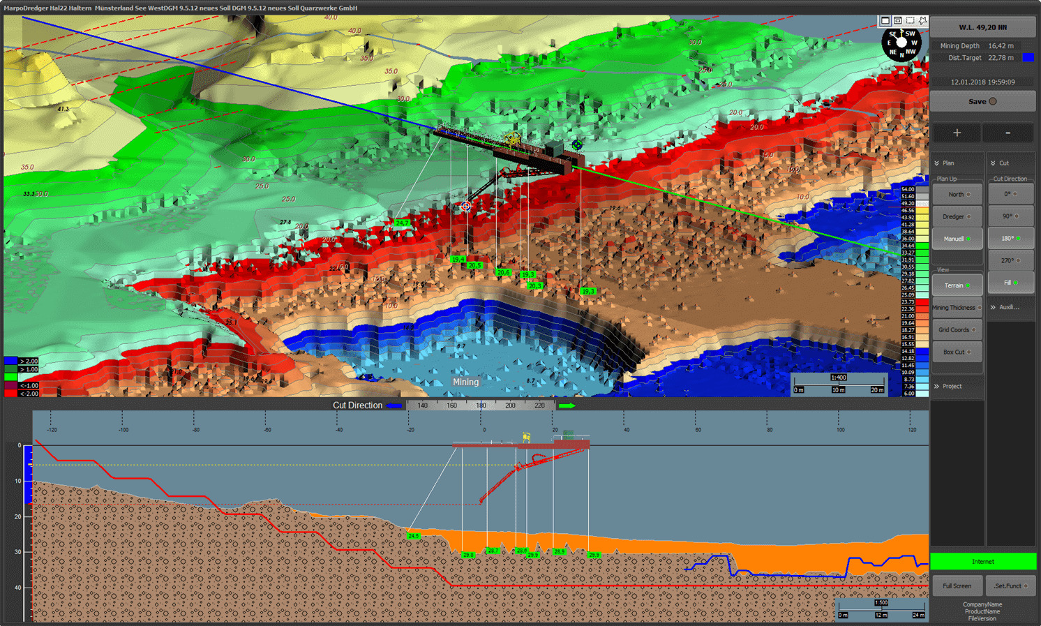
Figure: MARPO_DREDGER software. Upper window: 2D/3D view of the digital terrain model. Lower window: Profile cross-section view. Orientation, viewing direction and scale can be selected freely. The extraction process is visualized in real time.
The following data can be viewed during dredging on the on board TFT touchscreen monitor:
- field boundaries, extraction boundaries, slope gradients, extraction horizons, tolerance thresholds, and operating specifications;
- morphology of the water bed;
- target and actual slopes;
- extractible thickness at the current dredging position
- dredging obstacles, unproductive layers, and other special features of the deposit
- actual position of the excavation apparatus, contingent on commensurate positional accuracy (accuracy into decimetre range)
- success of the targeted areal removal, indicated by color-coded marking of insufficiently exploited field sections
- position of the anchor and anchor chain
Expansion options
Because of its modular structure it can be adapted to the respective operating conditions and augmented by numerous elements:
- Slope sonar, echo sounder, 360° sonar scanner
- Radio wave gauge
- Direct data transfer from the dredger to the computer of the operation management office
- Device for recording operating data (recording of machine data, such as power consumption, speed of the bucket wheel, flow rate, etc.)
- Remote visualization of the extraction process
- UPS
SPE Dredging Solutions GmbH
Klopstockstr. 13
D – 22765 Hamburg
Phone: +49(0)40 390 63 55
E-mail: info(at)spe-electronics.de
Legal notice | Privacy protection