EXPERTISE
EXPLORATIONExploration
Exploration of deposits of loose and solid rock
Exploration/surveying is the starting point for the installation of our MARPO dredge monitoring system, giving us an overview of the geology of the deposit as well as its current status. To ensure our customers always receive the best possible service and to provide them with detailed information regarding optimal reserves estimates/determination of the gravel remaining in their deposit, we survey with the help of echo sounders, multibeams and side scan sonar. For exploration we rely on geotechnical and geophysical methods such as seismology, drilling, pressure sounding and geoelectrics. With our geological expertise we can be relied on to supervise the extraction project and prevent the exceedance of extraction limits.
- Prospecting, exploration and evaluation of deposits
- Geological, geotechnical, hydrogeological, and geophysical exploration
- Determination of remaining gravel in flooded gravel pits
- Structural stability calculations
- Subsoil analyses
Combination of direct and indirect digestion methods
Boring:
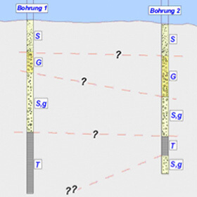
Geoelectrics:
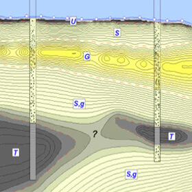
Deposit model:
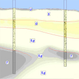
Geotechnical and geophysical exploration

Figure: Result of exploration of the deposit
Sand and gravel have always belonged to the most important raw materials in the world. This is why knowledge of the subsoil is so important for the efficient extraction of a deposit. Incomplete knowledge about a deposit can often lead to problems later on; sub-optimal extraction machinery may be employed, or the exploitation value or extraction timeframe may be estimated too optimistically.
Using geotechnical methods we can deliver precise information regarding local deposit conditions. These include bore samples, ramming core sounding, cone penetration tests, ground studies or geophysical studies involving seismology or geoelectricity. SPE Dredging Solutions GmbH takes charge of the planning and supervision of exploratory work and the evaluation and can then come to reliable conclusions regarding the condition, the density and the spatial location of individual layers.
The main goal of geoelectrical exploration is to be able to draw conclusions about the stratification of the ground, and to learn more about the continuity of the individual soil layers and their structural content. Our approach: a geoelectrical exploration of an area up to 200 meters in length with a penetration depth of up to 40 meters. The results are then displayed in the form of a 2D resistance tomography as a section of the subsurface.
To explore underwater deposits we also apply shallow seismic methods, with which we can reach exploration depths of up to 15 meters below the water bed. The combination of seismic and geoelectric measurements and geotechnical procedures such as ramming core sounding or shell and auger drilling can significantly improve the accuracy of deposit exploration and more produce more accurately calibrated geoelectric and seismic results. In the context of gravel and sand exploration, this forms the basis for an interpretation of deposit research.
Surveying onshore and with drones
To obtain an overall picture of a deposit, we offer surveying using a centimetre-precise RTK system. With this high-quality, satellite-protected GPS, our geologists not only determine the engineer’s survey, they also use the especially detailed data to chart the current reserves in a loose rock area. This makes it possible to map the overall surface and to calculate volumes that are still available and can be extracted. Repeat measurements make it possible to calculate volume changes.
In addition to this geodesic method, the SPE Dredging Solutions GmbH portfolio includes another survey technique that uses drones. Thanks to drone technology we can present our customers with new perspectives. The advanced technology allows us to create, not just a professional 3D map of the customer site, but also a visual map.
We offer the following surveying services:
- Position and elevation measurements in all common types and file formats
- Centimetre-precise RTK surveying
- Positioned echo sounding measurements to chart the water bed
- Creation of digital terrain models
- Site stakeouts
- Construction services accounting according to REB
(standardised rules for electronic calculations)
Hydrographic surveys (bathymetry)
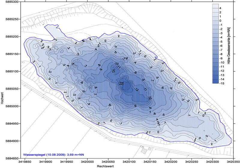
Figure: Echo sounder position-finding in a quarry pond
Since SPE Dredging Solutions GmbHs MARPO systems from are primarily installed on floating dredgers, it is essential to know the topographical features of the water or lake floor. Bathymetry, or hydrographic surveying, provides information on the depth profile of a body of water making it possible to determine the exact depth. The depth is determined on the basis of sound propagation, which is measured using different hydropgraphic sounding methods. These include, for example, echo sounders, which can provide information on water morphology based on the transit time of sound signals. Even more detailed information can be obtained using a multibeam, which, due to its higher density of measuring points, allows extensive mapping of the water bed. The third acoustic method we use to measure water bodies is the side scan sonar, which does not record the soil structure like a fan the same way an echo sounder does, but provides an three-dimensional accurate image.
We offer the following surveying services:
- Position and elevation measurements in all common types and file formats
- Positioned echo sounding, multibeam and side scan surveying to chart the water bed
- Creation of digital terrain models
- Determination of remaining gravel
- Assessment of the condition of underwater slopes
- Measurements of mud thickness

SPE Dredging Solutions GmbH
Klopstockstr. 13
D – 22765 Hamburg
Phone: +49(0)40 390 63 55
E-mail: info(at)spe-electronics.de
Legal notice | Privacy protection